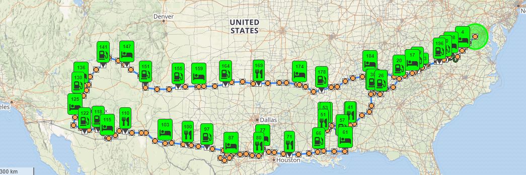
SpotWalla Trip Link
Click the link above to load the SpotWalla interactive trip viewer. When the viewer loads, click the route name in the top menu to configure how many points to display. For most detail, select Adjustments, then "%FILL" ,then "ALL", then Update Map. The map can be zoomed in an out for the desired viewing level. Screen updates will be slower while displaying all points.
I once attempted to leave home for a motorcycle trip with no plans and no destination. It was far too stressful! Planning a trip for me is enjoyable, and I find rewards in executing what I've planned. Yet I try to allow for spontaneous changes that take advantage of unexpected opportunities.
I've used Garmin GPS systems for 20 years; the current Garmin trip planning software is BaseCamp, which I generally use for planning. I'll often lay out a loose plan that spans several days at a time, with undetermined intermediate points to allow flexibility. If time allows, I may noodle a trip into existence over several months time. This was one of those trips, with two major geographic highlights: the Sonoran desert with its millions of amazing saguaro cacti along the southern US border, and Monument Valley on the border of Arizona and Utah. I'd slowly worked up the scenario during the winter months and coordinated it with our annual ride to MACH (Mississippi Area Crawfish Hunt) the first weekend each May, and working in a few days with our Mississippi family.
My Gold Wing on-board navigation system is made to Honda specs by Garmin, and has a data card that allows me to transfer trips, GPS logs, and waypoints between the bike and the PC. Once loaded to the data card, the GPS system then imports them for use while traveling. Transferring track logs from the GPS is similar but in reverse. I'm an inveterate GPS junkie and having a real-time map has allowed us to explore roads that I would never have trusted without being able to see the surrounding environment.
My Gold Wing motorcycle features Sirius XM Radio, Weather, and Traffic built into the audio and navigation system. One of the very coolest features is the ability to overlay the weather radar directly over the GPS route. This has helped us innumerable times in knowing whether we will need rain gear, or whether to wait out a big red splotch, or whether we can keep riding without rain gear. It also has screens with road conditions, wind and flood maps, and National Weather Service alerts. While moving, many of the interactive features are unavailable, but a single multi-function push button on the left handlebar performs a bewildering variety of functions and switching between screens.
Sirius XM Radio as an audio source is splendid because it follows us wherever we go, and there are channels for any musical taste or talk-show aficionado. On this trip, however, we listened to music only during one day, a little country music that seemed especially appropriate for Texas. Somehow being in the desert invites a sense of quietness. Riding together in splendid solitude through the ever-changing desert spectacle just didn't need improvement. We never talked about it. It was just the way it happened.
We pay close attention to apparel. We ascribe to a concept often called "ATGATT": All The Gear All the Time. Boots, jeans or protective pants, jackets, gloves and helmets. All the time while riding. Our Cruiserworks riding boots are waterproof, which eliminates the added effort of traveling with rain boots. Our Gold-Wing branded mesh jackets have two-layer liners for cooler weather, and we find we can travel comfortably in temperatures into the 40s with the liner and several layers of sweat shirts. In hot weather, it would seem the jackets would be hot but they are actually cooler than riding with direct sun on your skin, as long as we can keep moving. When we stop in town for red lights on a 90-degree day, then the jackets are hot! We generally travel with two pairs of gloves depending on the expected temperatures; in summer, we wear First Gear Ultra Mesh leather-palmed gloves.
And now, a word about underwear. One of the greatest contributors to a comfortable trip is underwear. Most underwear have seams, which create pressure points where the legs meet the seat; most underwear are cotton, which does a good job absorbing moisture but does nothing to transport the moisture away from the skin; and most underwear have a high coefficient of friction, which contributes to skin irritation. The answer to all this is a fabric and garment design invented by my friend Mario Winkelman, whose seamless products are branded as LD Comfort. These various garments, staples in the Long Distance Riding community, have added many hours to our comfort zone for each day's ride. I carry two pairs, along with several pairs of socks, and wash out a pair by hand every night using baby shampoo.
About a year ago I was diagnosed with mild Type II diabetes, so we've had to be a bit more careful about meal management and timing than in previous years. Typically we try to eat a robust protein-heavy breakfast. Being on the road it's often hard to find great lunch options, but Subway sandwiches often present themselves; nuts are a great snack with an amazing calorie density, and we always travel with some diabetic-friendly snack bars and pre-measured portions of nuts. At day's end, I usually try to find a hotel with a restaurant within walking distance. It takes some planning and perseverance to maintain that standard; and when our trip parameters changed and we had to "wing it" every day for the last week or so, that was very much hit-or-miss, but generally worked out anyway. On this trip, we both lost a little weight by being careful and yet enjoying our mealtimes together.
People often ask how many miles we travel per day, and there's no set answer. I think more about time in the saddle, and mileage is often a coincidental byproduct of the day's plan. However, it is rare that we spend more than one night in the same place. Kitty often says "It's a motorcycle ride - let's ride." However, I'm working on a Nova Scotia trip for the future that I've called "sprint and explore," where we will almost always stay for several nights at the same place and explore that area before moving on. It will be an experiment for us.
On this trip, we were blessed with amazing weather. We had hard rain for one day, riding from Vicksburg to Gulfport MS. One other morning, leaving Van Horn TX, we put on rain gear in case it was needed, but as much for warmth as for any rain. Otherwise, we encountered no rain at all. It was an extremely unsettled weather period across the country; in the places we would soon be, and in the places we had just left, strong weather seemed to pop up all over the place while we enjoyed moderate temperatures and sunny skies. One of my biggest concerns was hot weather in the deserts; in Gila Bend AZ, for example, where we were stranded on Mother's Day, temperatures of over 100 F had already been recorded. When we were there, the days were delightfully sunny with temperatures in the low 80's; the nights were chilly, in the 40's, not unusual in the desert. This trip may have set a new bar for near-perfect weather.
On this trip, we were blessed with amazing weather. We had hard rain for one day, riding from Vicksburg to Gulfport MS. One other morning, leaving Van Horn TX, we put on rain gear in case it was needed, but as much for warmth as for any rain. Otherwise, we encountered no rain at all. It was an extremely unsettled weather period across the country; in the places we would soon be, and in the places we had just left, strong weather seemed to pop up all over the place while we enjoyed moderate temperatures and sunny skies. One of my biggest concerns was hot weather in the deserts; in Gila Bend AZ, for example, where we were stranded on Mother's Day, temperatures of over 100 F had already been recorded. When we were there, the days were delightfully sunny with temperatures in the low 80's; the nights were chilly, in the 40's, not unusual in the desert. This trip may have set a new bar for near-perfect weather.
In Gila Bend AZ, Mother's Day Sunday, when I went to start the bike, it was stone cold dead. A minimal bit of troubleshooting revealed that there was an unexplained complete battery failure. The saga has been chronicled in earlier blog entries, but we were fortunate to be in a safe place, a hotel with a restaurant, and on Monday found a friendly face with a solution. We lost a day and a half of riding time, but with Kitty's urging, were able to re-incorporate several major components of the trip even though it meant several 500-mile days on the back end. In the end, we spent plenty of time among Saguaro cactus deserts and we saw the awesome spectacle of Monument Valley. From the beginning, that's what we had set out to see.
It was after that, in Farmington NM, that someone backed into the rig and pushed the bike onto its side with extensive damage. The driver was a stand-up guy and reported it to the hotel so proper exchange of information could take place. We rode 2,000 miles home with a shattered mirror that I taped together with electrical tape. It was a fractured experience to be sure, but after 2,000 miles of practice I became pretty good at sorting out which of the six or so vehicle images in the mirror was the one closest and needed to be accounted for. Once again, we were fortunate that we could recover and ride the bike home. As I write this, the motorcycle and trailer have both been completely restored and are back in my garage.
I've made references to a past Nova Scotia tour where we overnighted in a remote bed and breakfast with a tiny but famous restaurant, and where we discovered a plaque that instantly became the mantra of our lives, times, and all our trips: Together is the Best Place to Be.
This trip together, despite its unexpected challenges, turned out to be one of the most rewarding for me. After my dad's death last October, our family is finding its way to a new normal; this time together, isolated from the normal stresses of life, was a wonderful period of reflection and rejuvenation. Just being with Kitty made me a better person.
Truly, together is the best place to be.